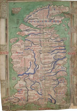
Cotton Claudius D vi, fol. 12v, Matthew Paris’s map of Britain: click the thumbnail to read more. Image appears by permission of the British Library.
A Map of Geoffrey of Monmouth’s Britain
Siân Echard, University of British Columbia
Most of the names on the large map below are (or will be) clickable (the cursor changes when placed over a clickable name). A smaller window will open with details of what Geoffrey has to say about the location in question (book and chapter numbers appear in bold after quotations). At present the translation is that of Lewis Thorpe (Harmondsworth, Middlesex: Penguin Books, 1966), though I plan to substitute my own translations in due course). There are also often notes drawn from J.S.P. Tatlock’s The Legendary History of Britain (Berkeley: University of California Press, 1950); these are indicated by page numbers. Sometimes there are references to Bede's Ecclesiastical History, and to the Historia Brittonum: no specific editions are cited, but chapter numbers are given. In most cases, there are also links in these small windows to external sites. You can resize the windows when you visit the external sites. The detail windows also have navigation buttons, so if you click the back button in the detail window after you’re finished looking at an external site, it will take you back to the text concerning the location in Geoffrey.
The outline for this map was downloaded from the Ordnance Survey of the UK. I have added the rivers and placenames myself, so they are not as exact as the outline is.
Please note: the map is very large. You’ll need to scroll around to find what you’re looking for.
Map taken down for complete overhaul, June 2019: This was an old project, and its code is outdated. I hope to update it, but it is likely to take some time.
